fbpx

News & Announcements


Plan Your Trip

HURRICANE FLORENCE UPDATE 2: CARTA Will End Emergency Service for the Day at 6 P.M.; Regular Operations to Continue Into Wednesday

EMERGENCY EVACUATION SERVICES ALSO AVAILABLE FROM 8 A.M. TO 6 P.M. WEDNESDAY, AS CONDITIONS PERMIT

CARTA will end emergency services at 6 p.m. on Tuesday, Sept. 11, and resume operating an emergency circulator on the Charleston Peninsula beginning at 8 a.m. on Wednesday, Sept. 12. The 14-stop circulator, which can be viewed here, will offer pick-up hourly. Regular operations, except Route 203 Medical Shuttle, will continue into Wednesday, as conditions permit.

The emergency circulator will run in addition to regular service until 6 p.m. on Wednesday, or until conditions become unsafe. Regular service will be available until conditions become unsafe. Riders on the emergency circulator will be taken to the Charleston County Public Service Building. The county will provide transportation to regional emergency shelters based on occupancy. All riders are encouraged to call the Charleston County Emergency Public Information Line at (843) 746-3900 with any questions.

Also until 6 p.m. and as conditions allow on Wednesday during the evacuation, CARTA will:

  • Transport those with mobility impairments (disabilities) to an appropriate shelter.
  • Transport individuals with pets who would like to evacuate to a pet-friendly shelter.

Contact the Charleston County Emergency Public Information Line at (843) 746-3900 and a vehicle will be dispatched to transport disabled residents and those with pets to directly to pet- and special needs-friendly evacuation shelters.

  • A map of the emergency route operated by CARTA and the pick-up points can be viewed at here.
    • CC-101: Bus stop at Meeting Street and Mary Street.
    • CC-102: Bus stop at Meeting Street and Johnson Street.
    • CC-103: Bus stop at Fishburne Street and Rutledge Avenue.
    • CC-104: Bus stop at King Street and Mt. Pleasant Street.
    • CC-105: Bus stop at Calhoun Street and Alexander Street.
    • CC-106: Bus stop at Beaufain Street and Market St. (Canterbury House).
    • CC-107: Bridgeview Village Apartments – 106 D. North Romney Street.
    • CC-108: Bus stop at Doscher Avenue and Peonie Street.
    • CC-109: Bus stop at Rutledge Avenue and Gordon Street.
    • CC-110: Bus stop at Rutledge Avenue and Cannon Street.
    • CC-111: Bus stop at Rutledge Avenue and Bennett Street.
    • CC-112: Bus stop at Broad Street and Logan Street.
    • CC-113: Bus stop at East Bay Street and Hassel Street.
    • CC-114: Bus stop at Morrison Drive and Romney Street.

The latest Hurricane Florence CARTA-related news can be found at ridecarta.com/Florence. Information will also be available on CARTA social media channels, @ridecarta on Facebook, Twitter and Instagram.

Hurricane Florence Update 1: CARTA Will Begin Emergency Circulator Service at Noon On Sept. 11

REGULAR SERVICE PLANNED TO CONTINUE INTO WEDNESDAY

CARTA will begin operating an emergency circulator on the Charleston Peninsula beginning at noon on Tuesday, Sept. 11. The 14-stop circulator, which can be viewed here, will offer pick-up hourly. All riders are encouraged to call the Charleston County Emergency Public Information Line at (843) 746-3900 with any questions.

The emergency circulator will run in addition to regular service all day Tuesday. CARTA anticipates operating at full capacity into Wednesday or until conditions become unsafe. Riders on the emergency circulator will be taken to the Charleston County Public Service Building. The county will provide transportation to regional emergency shelters based on occupancy.

In addition to the emergency circulator, as conditions allow during the evacuation, CARTA will:

  • Transport those with mobility impairments (disabilities) to an appropriate shelter.
  • Transport individuals with pets who would like to evacuate to a pet-friendly shelter.

Contact the Charleston County Emergency Public Information Line at (843) 746-3900 and a vehicle will be dispatched to transport disabled residents and those with pets to directly to pet- and special needs-friendly evacuation shelters.

  • A map of the emergency route operated by CARTA and the pick-up points can be viewed at here.
    • CC-101: Bus stop at Meeting Street and Mary Street.
    • CC-102: Bus stop at Meeting Street and Johnson Street.
    • CC-103: Bus stop at Fishburne Street and Rutledge Avenue.
    • CC-104: Bus stop at King Street and Mt. Pleasant Street.
    • CC-105: Bus stop at Calhoun Street and Alexander Street.
    • CC-106: Bus stop at Beaufain Street and Market St. (Canterbury House).
    • CC-107: Bridgeview Village Apartments – 106 D. North Romney Street.
    • CC-108: Bus stop at Doscher Avenue and Peonie Street.
    • CC-109: Bus stop at Rutledge Avenue and Gordon Street.
    • CC-110: Bus stop at Rutledge Avenue and Cannon Street.
    • CC-111: Bus stop at Rutledge Avenue and Bennett Street.
    • CC-112: Bus stop at Broad Street and Logan Street.
    • CC-113: Bus stop at East Bay Street and Hassel Street.
    • CC-114: Bus stop at Morrison Drive and Romney Street.

The latest Hurricane Florence CARTA-related news can be found at ridecarta.com/Florence. Information will also be available on CARTA social media channels, @ridecarta on Facebook, Twitter and Instagram.

CARTA Hurricane Florence Information

Please note CARTA service could be impacted well before landfall. If you rely on the system for transportation, please make preparations, such as trips to the store, now.

Information will be made available here on an on ongoing basis. Check back regularly for updates regarding CARTA service.


HURRICANE FLORENCE UPDATE 4
CARTA TO RESUME REGULAR SERVICE ON SUNDAY, SEPT. 16
INFORMATION ON ROUTES AND SCHEDULES AVAILABLE AT RIDECARTA.COM

NORTH CHARLESTON, S.C. (SEPT. 15, 2018) – In the aftermath of Hurricane Florence, CARTA will resume regularly scheduled service beginning Sunday, Sept. 16.

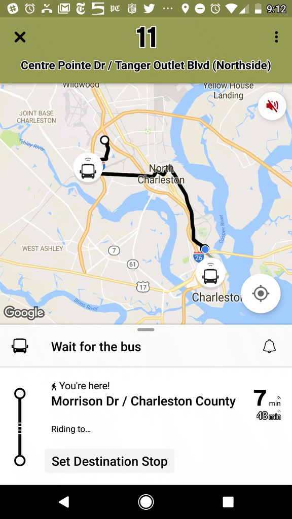
Riders can sign up for push alerts by downloading the Transit App on Apple or Android devices and selecting the routes for which they would like updates.

The latest CARTA news is available at RideCARTA.com and on CARTA social media channels, @ridecarta on Facebook, Twitter and Instagram.


SEPT. 15 A.M. UPDATE
Information regarding a return to regular service will be made available later today on our social media channels and at www.rideCARTA.com. Sign up for push alerts by downloading the Transit App for Apple or Android devices and selecting the routes for which you would like updates.


HURRICANE FLORENCE UPDATE 3
CARTA TO SUSPEND ALL OPERATIONS AT 9 P.M. SEPT.12
EMERGENCY EVACUATION SERVICES WILL BE AVAILABLE SEPT. 13 AT CHARLESTON COUNTY’S DIRECTION

NORTH CHARLESTON, S.C. (SEPT. 12, 2018) – CARTA will suspend all operations at 9 p.m. on Wednesday, Sept. 12. Limited emergency evacuation services will resume on Thursday, Sept. 13, at Charleston County’s direction.

CARTA will operate an emergency circulator on the Charleston Peninsula throughout the day Wednesday. The 14-stop circulator, which can be viewed here, will offer pick-up hourly.

The emergency circulator will run in addition to regular service until 9 p.m. on Wednesday. Riders on the emergency circulator will be taken to the Charleston County Public Service Building. The county will provide transportation to regional emergency shelters based on occupancy. All riders are encouraged to call the Charleston County Emergency Public Information Line at (843) 746-3900 with any questions.

In addition to the emergency circulator and regular service, until 9 p.m., CARTA will also:

  • Transport those with mobility impairments (disabilities) to an appropriate shelter.
  • Transport individuals with pets who would like to evacuate to a pet-friendly shelter.

Contact the Charleston County Emergency Public Information Line at (843) 746-3900 and a vehicle will be dispatched to transport disabled residents and those with pets to directly to pet- and special needs-friendly evacuation shelters.

  • A map of the emergency route operated by CARTA and the pick-up points can be viewed at here.
    • CC-101: Bus stop at Meeting Street and Mary Street.
    • CC-102: Bus stop at Meeting Street and Johnson Street.
    • CC-103: Bus stop at Fishburne Street and Rutledge Avenue.
    • CC-104: Bus stop at King Street and Mt. Pleasant Street.
    • CC-105: Bus stop at Calhoun Street and Alexander Street.
    • CC-106: Bus stop at Beaufain Street and Market St. (Canterbury House).
    • CC-107: Bridgeview Village Apartments – 106 D. North Romney Street.
    • CC-108: Bus stop at Doscher Avenue and Peonie Street.
    • CC-109: Bus stop at Rutledge Avenue and Gordon Street.
    • CC-110: Bus stop at Rutledge Avenue and Cannon Street.
    • CC-111: Bus stop at Rutledge Avenue and Bennett Street.
    • CC-112: Bus stop at Broad Street and Logan Street.
    • CC-113: Bus stop at East Bay Street and Hassel Street.
    • CC-114: Bus stop at Morrison Drive and Romney Street.

The latest Hurricane Florence CARTA-related news can be found at ridecarta.com/Florence. Information will also be available on CARTA social media channels, @ridecarta on Facebook, Twitter and Instagram.


HURRICANE FLORENCE UPDATE 2
CARTA WILL END EMERGENCY SERVICE FOR THE DAY AT 6 P.M.; REGULAR OPERATIONS TO CONTINUE INTO WEDNESDAY
EMERGENCY EVACUATION SERVICES ALSO AVAILABLE FROM 8 A.M. TO
6 P.M. WEDNESDAY, AS CONDITIONS PERMIT

NORTH CHARLESTON, S.C. (SEPT. 11, 2018) – CARTA will end emergency services at 6 p.m. on Tuesday, Sept. 11, and resume operating an emergency circulator on the Charleston Peninsula beginning at 8 a.m. on Wednesday, Sept. 12. The 14-stop circulator, which can be viewed here, will offer pick-up hourly. Regular operations, except Route 203 Medical Shuttle, will continue into Wednesday, as conditions permit.

The emergency circulator will run in addition to regular service until 6 p.m. on Wednesday, or until conditions become unsafe. Regular service will be available until conditions become unsafe. Riders on the emergency circulator will be taken to the Charleston County Public Service Building. The county will provide transportation to regional emergency shelters based on occupancy. All riders are encouraged to call the Charleston County Emergency Public Information Line at (843) 746-3900 with any questions.

Also until 6 p.m. and as conditions allow on Wednesday during the evacuation, CARTA will:

  • Transport those with mobility impairments (disabilities) to an appropriate shelter.
  • Transport individuals with pets who would like to evacuate to a pet-friendly shelter.

Contact the Charleston County Emergency Public Information Line at (843) 746-3900 and a vehicle will be dispatched to transport disabled residents and those with pets directly to pet- and special needs-friendly evacuation shelters.

  • A map of the emergency route operated by CARTA and the pick-up points can be viewed at here.
    • CC-101: Bus stop at Meeting Street and Mary Street.
    • CC-102: Bus stop at Meeting Street and Johnson Street.
    • CC-103: Bus stop at Fishburne Street and Rutledge Avenue.
    • CC-104: Bus stop at King Street and Mt. Pleasant Street.
    • CC-105: Bus stop at Calhoun Street and Alexander Street.
    • CC-106: Bus stop at Beaufain Street and Market St. (Canterbury House).
    • CC-107: Bridgeview Village Apartments – 106 D. North Romney Street.
    • CC-108: Bus stop at Doscher Avenue and Peonie Street.
    • CC-109: Bus stop at Rutledge Avenue and Gordon Street.
    • CC-110: Bus stop at Rutledge Avenue and Cannon Street.
    • CC-111: Bus stop at Rutledge Avenue and Bennett Street.
    • CC-112: Bus stop at Broad Street and Logan Street.
    • CC-113: Bus stop at East Bay Street and Hassel Street.
    • CC-114: Bus stop at Morrison Drive and Romney Street.

The latest Hurricane Florence CARTA-related news can be found at ridecarta.com/Florence. Information will also be available on CARTA social media channels, @ridecarta on Facebook, Twitter and Instagram.


HURRICANE FLORENCE UPDATE 1
CARTA WILL BEGIN EMERGENCY CIRCULATOR SERVICE AT NOON ON SEPT. 11
REGULAR SERVICE PLANNED TO CONTINUE INTO WEDNESDAY

NORTH CHARLESTON, S.C. (SEPT. 10, 2018) – CARTA will begin operating an emergency circulator on the Charleston Peninsula beginning at noon on Tuesday, Sept. 11. The 14-stop circulator, which can be viewed here, will offer pick-up hourly. All riders are encouraged to call the Charleston County Emergency Public Information Line at (843) 746-3900 with any questions.

The emergency circulator will run in addition to regular service all day Tuesday. CARTA anticipates operating at full capacity into Wednesday or until conditions become unsafe. Riders on the emergency circulator will be taken to the Charleston County Public Service Building. The county will provide transportation to regional emergency shelters based on occupancy.

In addition to the emergency circulator, as conditions allow during the evacuation, CARTA will:

  • Transport those with mobility impairments (disabilities) to an appropriate shelter.
  • Transport individuals with pets who would like to evacuate to a pet-friendly shelter.

Contact the Charleston County Emergency Public Information Line at (843) 746-3900 and a vehicle will be dispatched to transport disabled residents and those with pets directly to pet- and special needs-friendly evacuation shelters.

  • A map of the emergency route operated by CARTA and the pick-up points can be viewed at here.
    • CC-101: Bus stop at Meeting Street and Mary Street.
    • CC-102: Bus stop at Meeting Street and Johnson Street.
    • CC-103: Bus stop at Fishburne Street and Rutledge Avenue.
    • CC-104: Bus stop at King Street and Mt. Pleasant Street.
    • CC-105: Bus stop at Calhoun Street and Alexander Street.
    • CC-106: Bus stop at Beaufain Street and Market St. (Canterbury House).
    • CC-107: Bridgeview Village Apartments – 106 D. North Romney Street.
    • CC-108: Bus stop at Doscher Avenue and Peonie Street.
    • CC-109: Bus stop at Rutledge Avenue and Gordon Street.
    • CC-110: Bus stop at Rutledge Avenue and Cannon Street.
    • CC-111: Bus stop at Rutledge Avenue and Bennett Street.
    • CC-112: Bus stop at Broad Street and Logan Street.
    • CC-113: Bus stop at East Bay Street and Hassel Street.
    • CC-114: Bus stop at Morrison Drive and Romney Street.

WHAT TO KNOW

I. Please call Charleston County Emergency Public Information Line at (843) 746-3900 if:

  • You have questions or need to make a request regarding transportation.
  • You need transportation to the nearest shelter during a voluntary or mandatory evacuation.
  • You are disabled and cannot get to the nearest evacuation pick up point.

II. CARTA’s Role During a Hurricane: What to Expect

  • If a mandatory evacuation has been called for, expect CARTA services to be suspended within 24-48 hours in order to assist with evacuation efforts. This could happen with very little warning.
  • As conditions deteriorate, all CARTA vehicles will be removed from the road within 24-48 hours of expected landfall.
  • Please plan accordingly and make any trips to purchase supplies in advance of an evacuation order or as quickly as possible once the evacuation has been called for.

III. Transportation During an Evacuation

  • If an evacuation is ordered and you do not have transportation in Charleston County, buses will be provided to take you from assigned pick-up points to the Charleston County Public Services Building and then to the nearest available shelter out of the area. Look for blue Hurricane Evacuation Bus Stop signs designating a pick-up point location near you.
  • CARTA will begin operating an emergency circulator on the Charleston Peninsula beginning at noon on Tuesday, Sept. 11. The 14-stop circulator, which can be viewed here, will offer pick-up hourly. All riders are encouraged to call the Charleston County Emergency Public Information Line at (843) 746-3900 with any questions.
  • Be aware that the buses sent will most likely be yellow school buses, not CARTA buses.
  • For a list of the pick-up points please visit charlestoncounty.org.

IV. During an Evacuation, CARTA’s Main Role Is … :

  • To transport those with mobility impairments (disabilities) to an appropriate shelter.
  • To transport individuals with pets who would like to evacuate to a pet-friendly shelter. If you have an animal to bring with you while evacuating and do not have transportation, contact the Charleston County Emergency Public Information Line at (843) 746-3900 and a vehicle will be dispatched to transport you and your pet(s) to a pet friendly evacuation shelter.
  • CARTA also runs an on-demand downtown Charleston Peninsula route at the request of Charleston County to assist with picking up individuals from stops with the blue hurricane signs.
  • Once a request has been made, individuals will need to be at the bus stop with blue hurricane evacuation sign in order to be picked up. These stops are often located near a regular CARTA bus stop, but you should become familiar with where your stop is in advance of any emergency. Visit ridecarta.com during the evacuation for more details.
  • CARTA Customer service may not be available at times prior, during and after the storm. Contact the Charleston County Emergency Line at (843) 746-3900 for all transportation needs during an emergency. During an evacuation CARTA service will ONLY take you to the shelter.

V. CARTA Emergency Circulator Pick-Up Points

  • CARTA emergency service commence following the Governor’s call for an evacuation. The planned route is designed to offer pick-up every 60 minutes. Call the Charleston County Emergency Public Information Line at (843) 746-3900 with any questions.
  • A map of the emergency route operated by CARTA and the pick-up points can be viewed at here.
    • CC-101: Bus stop at Meeting Street and Mary Street.
    • CC-102: Bus stop at Meeting Street and Johnson Street.
    • CC-103: Bus stop at Fishburne Street and Rutledge Avenue.
    • CC-104: Bus stop at King Street and Mt. Pleasant Street.
    • CC-105: Bus stop at Calhoun Street and Alexander Street.
    • CC-106: Bus stop at Beaufain Street and Market Street (Canterbury House).
    • CC-107: Bridgeview Village Apartments – 106 D. North Romney Street.
    • CC-108: Bus stop at Doscher Avenue and Peonie Street.
    • CC-109: Bus stop at Rutledge Avenue and Gordon Street.
    • CC-110: Bus stop at Rutledge Avenue and Cannon Street.
    • CC-111: Bus stop at Rutledge Avenue and Bennett Street.
    • CC-112: Bus stop at Broad Street and Logan Street.
    • CC-113: Bus stop at East Bay Street and Hassel Street.
    • CC-114: Bus stop at Morrison Drive and Romney Street.

VI. After the Storm:

  • CARTA will assist at the direction of Charleston County with getting residents back to their homes from shelters
  • CARTA will resume regular services on a route-by-route basis as road and weather conditions permit.
  • Visit ridecarta.com for information and updates relating to CARTA services before, during and after the storm.

SHELTER INFORMATION

This is a revised listing of the shelters being used for Hurricane Florence in priority of use. Please note that this is the proposed order of shelters that evacuees will be sent to.

Berkeley County:
Shelter 1:
Goose Creek High School
1137 Red Bank Road
Goose Creek, SC 29445
Capacity:  1,500

Cane Bay High School: Pet Shelter (evacuees with pets only)
1624 State Road
Summerville, SC
Capacity:  1,659

Westview Primary School: Special Needs Shelter
98 Westview Drive
Goose Creek, SC 29445
Capacity: 100 special needs persons with their care providers (Total of 200)

Dorchester County:
Shelter 2A:
Newington Elementary School
10 King Charles Circle
Summerville, SC 29485
Capacity:  343

Shelter 2B:
Flowertown Elementary School
20 King Charles Circle
Summerville, SC 29485
Capacity:  382

Shelter 3:
Summerville Elementary School
835 South Main Street
Summerville, SC 29483
Capacity:  328

Orangeburg County (Used as necessary):
William Clark Middle School
919 Bennet Street
Orangeburg, SC 29115
Capacity: 419

Carver-Edisto Middle School
2018 Carver School Road
Cordova, SC 29039
Capacity: 347

Edisto Elementary School
136 Woodolive Street
Orangeburg, SC
Capacity: 434

Edisto Primary School
3239 Cordova Road
Cordova, SC 29039
Capacity: 523


GENERAL TIPS
Make a Plan:

  • Decide whether to evacuate or shelter in your home before the storm
  • Create a network of neighbors, friends and relatives to assist you in an emergency
  • Inform your family and friends of your plan and determine how you will maintain contact with one another
  • Stay in touch – stay informed. Listen to your radio or TV, and keep aware of changes that could require mandatory evacuation
  • Be realistic about your ability to manage alone, during, and after a storm
  • Download Charleston County’s 2018 Hurricane Guide for information on building an emergency supply kit, preparing your home, evacuation zones routes and other important information.
  • Download current Charleston County hurricane information.
  • The City of Charleston Hurricane web page

Create a List

  • Prepare for loss of power where you won’t have access to your cell phone or computer
  • Write a list of resources, contacts and important information: phone numbers of friends and family members, primary care physician, pharmacist, and your local police/ fire department
  • Collect and protect documents. In case of flooding, make sure copies of important papers, personal identification, insurance policies, social security cards and birth certificates are all in one place – ideally sealed in a plastic bag


September 9, 2018 Route Changes

On Sunday September 9, 2018 several routes will have minor modifications to improve the efficiency and on time performance.

Please click on the individual schedules below for details on all modifications.

HOP Route 7

  • HOP route 7 will have modifications to the late night hours – view the schedule for details

Route 13 Remount Road

  • Rt. 13 will now service Hanahan City Hall

Route 20 King Street

  • Slight schedule changes to improve efficiency.  Route will no longer serve the shelter on Mt. Pleasant St. on the first southbound trip.  Please board on the King St. side of Joseph Floyd Manor. CARTA encourages those with mobility devices to board on King St. as a safety precaution.

Route 30 Savannah Hwy

  • Slight schedule changes to Sunday schedule only to improve efficiency

Route 40 Mt. Pleasant

  • Slight schedule changes to Sunday schedule only to improve efficiency

Route 42 Wando Circulator

  • Slight schedule changes to Sunday schedule only to improve efficiency

Route 104 Montague Ave.

  • Slight schedule changes to improve efficiency

HOP Shuttle Ridership Surpasses 11,400 in August, Again Sets Record

OFFICIALS ANNOUNCE ADJUSTMENTS TO SERVICE TIMING

Ridership on the Charleston Area Regional Transportation Authority’s (CARTA) Hospitality on Peninsula (HOP) shuttle surpassed 11,400 in August, the fourth-straight record-setting month for the pilot park-and-ride program and up more than 1,400 riders over the previous month.

System officials also announced a number of adjustments to the popular service, effective Monday, Sept. 9:

  • Monday – Thursday (Last trip leaves the HOP lot at 1 a.m.)
    • 6 a.m. – 12:15 a.m.: Two buses run (every 15 minutes)
    • Midnight – 1:30 a.m.: One bus runs (every 30 minutes)
  • Friday and Saturday (Last trip leaves the HOP lot at 2 a.m.)
    • 6 a.m.-12:15 am.: Two buses run (every 15 minutes)
    • 12:00 a.m.-1:30 a.m.: One bus runs (every 30 minutes)
  • Sunday (Last trip leaves the HOP lot at 1 a.m.)
    • 6 a.m.-1:30 a.m.: One bus runs (every 30 minutes)

The park-and-ride program is the first of its kind on the peninsula and was brought to fruition via a collaborative partnership with the City of Charleston, Charleston County, the Charleston Area Convention and Visitors Bureau and the Berkeley-Charleston-Dorchester Council of Governments. The final ridership for the HOP in August was 11,417.

Visitors to downtown Charleston and all other commuters are also encouraged to park all day for just $5 and ride the HOP shuttle for free. Riders can track buses in real-time on the Transit app available on iPhone and Android.

“We are incredibly happy with the continued success of the HOP, as well as recent financial commitments from the City of Charleston and the private sector,” said Mike Seekings CARTA board chairman. “This initiative is proving successful and there is room for even more growth.”

September Service Impacts

The following service impacts will occur due to special events and inclement weather throughout the Lowcountry region during the month of September.

  • King Tides (Sept. 7-9, 6:30 p.m.-9:00 p.m.): Flooding in the usual areas, Routes 11 and 213.
  • Southern Fried Chicken Challenge (Sept. 8, 12 p.m.-6 p.m.): Riverfront Park at 1001 Everglades Ave, North Charleston.
  • Shaggin’ on the Cooper (Sept. 8, 7 p.m.): Mt. Pleasant Pier, at 71 Harry Hallman Blvd., Mt. Pleasant.
  • 2nd Sunday on King St. (Sept. 9, 1 p.m.-5 p.m.): King St. from Calhoun St. to Queen St. closed off.
  • CHS Beer Week Block Party (Sept. 15, 11 a.m.-6 p.m.): O’Hear Ave. from East Montague Ave. and Stone’s Alley Rd. (should not impede Route 104).
  • Charleston Pride Parade (Sept. 22, Begins 9 a.m.): Rolling closure from Ann St. to King St. onto Broad St. (Ann St. will be closed until the parade moves onto King St.).
  • MOJA Art Festival (Sept. 27, 6 p.m.-6:45 p.m.): Rolling closure from Marion Sq. on King St. to Market St. onto S. Market St. onto Concord St. (Route 211, potential Express impact crossing Calhoun).
  • 2018 Komen Lowcountry Race for the Cure (Sept. 22, 8 a.m.-12 p.m.): Riverfront Park at 1001 Everglades Ave., North Charleston. (Route 104 will have to use St. John Ave.).
  • Oktoberfest (Sept. 29, 11 a.m.-6 p.m.): O’Hear Avenue between Empire Ave. and Factory Dr. (should not impede the Route 104).
  • 2018 Lowcountry Heart Walk (Sept. 29, 9 a.m.-12 p.m.): Riverfront Park at 1001 Everglades Ave., North Charleston. (Route 104).

BCDCOG Receives $1.5 Million in Federal Grant Funds for Battery-Electric Buses

Council partnered with S.C.-based bus manufacturer Proterra

The Berkeley-Charleston-Dorchester Council of Governments (BCDCOG) has been awarded $1.5 million in funding as a part of the Federal Transportation Authority (FTA) Low- or No-Emission (Low-No) Grant program.

BCDCOG, one of 23 agencies nationwide to receive funds, will purchase an initial trio of zero-emission, battery-electric vehicles from Greenville, S.C. manufacturer Proterra, with whom it partnered on the grant application. The buses will be part of the Charleston Area Regional Transportation Authority (CARTA) fleet. BCDCOG has managed the transit authority since 2015.

“This is yet another step forward for public transportation in the region,” said BCDCOG and CARTA executive director Ron Mitchum. “Our staff worked diligently to secure funding for these clean-fuel vehicles, which will be the first of many on tri-county streets and highways.”

The CARTA board of directors in July passed a resolution to transition its entire fleet of fixed-route buses, primarily 1996 models that serviced the Atlanta Olympics, to zero-emission battery-electrics over the next several years. Funding from another federal grant program, when combined with Low-No resources, could see the number of battery-electric vehicles increase to as many nine in the near-term. CARTA is in the midst of updating its Express buses and has recently replaced its entire Downtown Area Shuttle (DASH) and Tel-A-Ride paratransit fleets.

A cornerstone of the Fixing America’s Surface Transportation (FAST) Act signed into law by Congress in December of 2015, the Low-No Grant program is centered on modernizing transit systems through the purchase of buses which are powered by hybrid or battery engines, according to a Proterra release.

More than $84 million in funding is being made available for 52 projects in 41 states via the Low-No program. About $36 million will be spent on Proterra buses nationally.

“We are extremely happy to see American-made, zero-emission vehicles making their way into our fleet,” said CARTA board of directors chairman Mike Seekings. “Reliable, eco-friendly buses are a core component of what we’re building in regard to public transit in the region.”

Intelligent Transportation System Request for Proposal

Description:

The purpose of this Request for Proposals is to purchase and install a well proven, industry standard, integrated package of public transit ITS hardware and software intended to assist dispatch and communications, capture data for transit system planning and management analysis, facilitate enhanced safety and security and provide enhanced public information.

Solicitation #: COG2018-04

Submit Offer By: Mon, 10/01/2018 – 15:00

Direct Inquiries To: Jason McGarry

Buyer Phone Number: 843-529-0400 x 221

Buyer Email: jasonm@bcdcog.com

Pre-Bid Information:

Delivery Point: 1362 McMillan Ave, Suite 100 North Charleston, SC 29405

Download Form

HOP Shuttle Sets Ridership Record for Third Straight Month, Surpasses 10,000 for first time

Ridership on the Charleston Area Regional Transportation Authority’s Hospitality on Peninsula (HOP) Shuttle surpassed 10,000 in July, the third-straight record-setting month for the pilot park-and-ride program.

“There is clear demand and need for this service, which has proven particularly valuable to the hospitality and food and beverages industries,” said CARTA board chairman Mike Seekings. “We hope that the resources necessary to continue the HOP’s momentum will be made available by the partners, both public and private, who have benefited from it, and that the program can be expanded to other parts of the city in the future.”

The park-and-ride program is the first of its kind on the peninsula and was brought to fruition via a collaborative partnership between the City of Charleston, Charleston County, the Charleston Area Convention and Visitors Bureau and the Berkeley-Charleston-Dorchester Council of Governments. Total ridership on the HOP in July was 10,015.

Service is currently scheduled for about every 15 minutes between 6 a.m. and 3 a.m., seven days per week. Visitors to downtown Charleston and all commuters are encouraged to park all day for just $5 and ride the HOP shuttle for free.

Seekings noted that the HOP will be a convenient option for College of Charleston students who live off the peninsula and drive downtown. Riders can track buses in real-time on the Transit app available on iPhone and Android. 

Get all the details on The HOP: www.ridecarta.com/HOP

Plan Your Trip
Transit App

Download “Transit” and travel like a true Charlestonian.

Available in the App Store and on Google Play, “Transit” offers numerous features to help you easily navigate around Charleston.

Bus Route: See vehicle locations in real time, find nearby stops, and receive stop announcements.

Service Alerts: Keep on top of schedule changes, stop relocations and other unexpected surprises.

Favorites: Always take the same bus? Move it to the top of the list by adding it to your favorites.

Timetables: View the full schedule for a route and set alarms to remind you to leave.

Countdowns: Get real-time predictions based on data from the transit agency.

“Go”: Get step-by-step transit directions and notifications about when to leave for your trip and when to get off the bus.

Plan a trip!: Compare trips side by side with your preferred transport modes selected.

View Transit 101

Download TransitApp from Google Play Store
Download TransitApp from Apple Store
TransitApp